views
After recording the lowest-ever August rainfall last month, major parts of India continue to reel under the impact of a weak monsoon. The seasonal rainfall deficit has widened to 11%.
Of the total 36 sub-divisions, as many as 12 are currently rain-deficient. This includes large parts of the Indo-Gangetic plains from East Uttar Pradesh, Bihar, Jharkhand, West Bengal as well as West Madhya Pradesh, parts of Maharashtra and South Karnataka. The monsoon has remained largely unfavourable for the region since its onset in June.
The latest weather forecast indicates there is still some time before the monsoon gains momentum over the region. Northwest India is expected to be largely dry over the next week, except for some scattered rainfall activity in the Himalayan states. However, the India Meteorological Department (IMD) is confident that the rainfall is likely to be normal for the country as a whole over the next two weeks. The monsoon remains active over north peninsular, central and east India with isolated heavy rain in Odisha, West Madhya Pradesh, Maharashtra and Gujarat for the next two to three days.
Meteorologists say a weak El Niño has begun to cast its influence over the monsoon, and it is likely to further intensify till early next year. The ocean phenomenon characterised by warm sea-surface temperatures (SSTs) is unfavourable for the Indian monsoon. However, this time, its effect is counterbalanced by the positive Indian Ocean Dipole (IOD) – another phenomenon which is good for monsoon rains.

Highly dependent on the monsoon, India had recorded its lowest-ever August rainfall last month which ended with 36% less rain than its long period average (LPA). The last time August saw such a low rain was in 2005. A staggering deficit was observed especially over Central India and South Peninsular India, where the rainfall was lowest-ever since 1901. According to the weather department, it was mainly due to a highly unfavourable monsoon trough, which lay mostly north to its normal position. The monsoon had entered a prolonged break phase, which continued from August 5 to 16 and then from August 27 to 31.
Only two low-pressure systems (LPAs) formed against normal of five, and August ended up with just nine low-pressure system days against the normal of 16.3 days. In the north, five Western Disturbances (WDs) impacted the Western Himalayan region against the normal of 2-3 WDs. However, most of these systems caused rainfall mainly in Himachal Pradesh and Uttarakhand, even triggering floods and landslides.

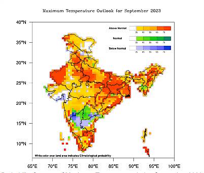
It was also the warmest-ever August for India with the mean temperature of 28.45°C – highest-ever since 1901 against the earlier record of 2009. The average maximum temperature also broke an all-time record and touched 32.19°C – nearly 1°C above normal.
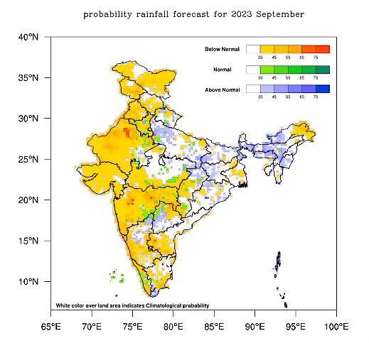
According to the IMD, monthly rainfall for September is most likely to be normal for the country as a whole. It defines ‘normal’ as 91-109% of Long Period Average (LPA) for the month. While the rains are likely to be ‘normal’ over many areas of northeast India, adjoining east India, foothills of Himalayas and some areas of east-central and south peninsular India, rest of the country may witness below-normal rains.


Comments
0 comment