views
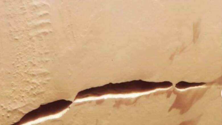
A 600-kilometer-long snaking scar on the surface of Mars has been captured in previously unseen detailed photographs by the European Space Agency’s (ESA) Mars Express mission. The unique zebra-like stripes that accompany the dark ravine are most likely a consequence of intense volcanic activity that occurred millions of years ago. According to the ESA, the remarkable surface feature known as Aganippe Fossa is a graben, which is a “ditch-like groove with steep walls on either side.” US Geological Survey data indicates that although it was discovered in 1930, astronomers did not officially name it until 1976.
Sharing the pictures on Instagram, ESA labelled them as “the scars of Mars.”
The Space Agency went on to give a brief description of the same. It claimed that this “giant crack” cuts across the slope of Arsia Mons, one of Mars’ most powerful volcanoes. According to scientists, the Martian crust was torn and stretched by magma, creating this gash. The surrounding topography suggests old glaciers and wind-blown dust, according to ESA.
View this post on Instagram
The post has more than 13,000 likes on the social media platform.
A user commented saying, “What a shot. Quite amazing & puzzling, the crust of Mars.”
Another user stated, “Beautiful scars! The amount of history and knowledge they hold is just magical.”
“Maybe Mars has a mysterious past,” read another comment.
Yet another user simply stated, “Amazing.”
These images were published by ESA’s Mars Express mission. This is Europe’s first mission to the Red Planet, which has been circling the planet since 2003.
The spacecraft continues to analyse Mars globally even after its lander, Beagle 2, was lost. It explores the planet’s blob-shaped moons, Phobos and Deimos, catalogues minerals, examines the atmosphere and looks into the crust.
According to a press release from ESA, two distinct types of terrain were photographed by Mars Express’s High Resolution Stereo Camera (HRSC): lobate terrain, which is composed of gently sloping cliffs and rocky debris, and so-called hummocky terrain, which is made up of numerous irregularly shaped mounds and valleys grouped together.
This striking divergence was probably brought about by long-term wind erosion that eroded the planet’s surface to the right of the graben. It’s unknown, though, why the remainder of the surrounding terrain remained unaffected.


Comments
0 comment