views
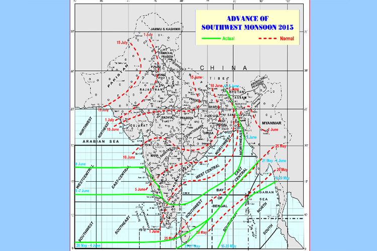
New Delhi: This is the most important season of the year for Western India starting from Kerala to Gujarat. The South-West Monsoon brings torrential rains and joy for the next four months. This year the arrival of Monsoon has been late by almost a week. The Monsoon which normally enters India by making landfall at Kovalam beach near Thiruvananthapuram on June 1, arrived on June 5. The wind was weak and most parts of Kerala got only some drizzle.
Monsoon arrived in Karnataka on June 7 bringing rain to the coast and Western Ghats areas of the state. The people were happy that the Monsoon has finally arrived. However, their joy turned into worry after they realised that the deep depression in the Arabian Sea has intensified and preventing the advance of Monsoon.
The Met department has already predicted that there would be a deficit Monsoon in 2015. The Cyclone has added to the concerns over normal Monsoon. In 2014, a similar depression in the Arabian Sea had delayed the settling of Monsoon by almost three weeks.
According to weather experts the deep depression in the Arabian Sea has intensified into cyclonic storm "Ashobaa" and is expected to further develop into a "super cyclonic storm" in next 24-36 hours.
An agency report says that "Ashobaa", centred over the east-central Arabian Sea, remained practically stationary for several hours about 590 km west-south-west of Mumbai. It is expected to move initially north-northwest and intensify further into a severe cyclonic storm during the next 36 hours, said an India Meteorological Department (IMD) bulletin. Under its influence, rainfall will occur at most places, with isolated heavy showers over coastal Karnataka, Konkan and Goa, and south Gujarat during the next 24 hours.
A report in 'Deccan Herald' says that strong winds, with speeds reaching 70-80 kmph and gusting to 90 kmph, would prevail along and off Karnataka, Goa and Maharashtra coasts over the next 24 hours, and rise to 90-100 kmph, gusting to 120 kmph, during the subsequent 24 hours. The sea condition is expected to be very rough to high along and off Karnataka, Goa and Maharashtra coasts over the next 48 hours. With the storm expected to move towards Oman, the Gujarat administration has heaved a sigh of relief.
Meanwhile, the southwest monsoon showed the first signs of force in Kerala on Monday, with parts of Kannur, Thrissur and Alappuzha districts recording heavy rainfall.
However, the Met department has predicted heavy rain at many places in the state till Friday. People living in coastal regions of Kerala, Karnataka, Goa and Maharashtra have commenced contingency measures to face the possible threat of rising tidal waves.


Comments
0 comment