views
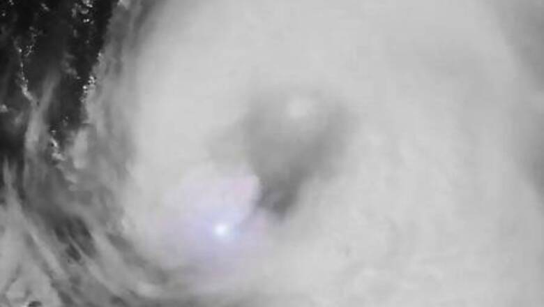
PORT ARTHUR, Texas: Hurricane Laura barreled toward the Gulf Coast on Wednesday as a massive Category 4 storm that was strengthening and forecast to cause catastrophic damage and “unsurvivable storm surge” along the Texas and Louisiana border, the National Hurricane Center said.
Laura, located 120 miles (190 km) south-southeast of Port Arthur on Wednesday afternoon, had maximum sustained winds of 150 miles per hour (240 km per hour) in the hours before landfall late Wednesday or early Thursday, the Miami-based forecaster said.
The oil-refining town of Port Arthur was directly in Laura’s path, the NHC forecast. The city of 54,000 was a ghost town on Wednesday afternoon, with just a couple of gas stations and a liquor store open for business.
“People need their vodka,” said Janaka Balasooriya, a cashier, who said he lived a few blocks away and would ride out the storm at home.
The sky over Port Arthur was a gray blanket, with ominous dark clouds approaching out in the Gulf. Wind and rain came in cycles as the hurricane’s outer bands arrived.
Eric Daw, a 58-year-old Port Arthur resident, filled up his car at the Fuel Depot.
He said he had wanted to evacuate earlier but lacked money for gas as he was waiting on a disability payment. He was headed to a shelter in San Antonio, a 4-1/2-hour drive, where instead of worrying about the storm he has to contend with COVID-19, echoing concerns of many others.
“They say we are all supposed to socially distance now,” he said. “But how am I supposed to socially distance in a shelter?”
MANDATORY EVACUATIONS
Some 620,000 people were under mandatory evacuation orders in Louisiana and Texas.
The catastrophic storm surge could penetrate up to 40 miles (64 km) inland from the coastline between Freeport, Texas, and the mouth of the Mississippi River and could raise water levels as high as 20 feet (6 m) in parts of Cameron Parish, Louisiana, the NHC said.
“To think that there would be a wall of water over two stories high coming on shore is very difficult for most to conceive, but that is what is going to happen,” said National Weather Service meteorologist Benjamin Schott at a news conference. Most of Louisiana’s Cameron Parish would be underwater at some point, Schott added.
“The word ‘unsurvivable’ is not one that we like to use, and it’s one that I’ve never used before,” Schott said of the storm surge.
Temporary housing was being hastily organized outside the storm surge zone for evacuated residents, and emergency teams were being strategically positioned, state and federal emergency management agencies said.
Federal Emergency Management Agency (FEMA) Administrator Pete Gaynor posted pictures of portable shelters at Camp Beauregard, Louisiana, about 115 miles (185 km) north of the Gulf Coast.
Texas Governor Greg Abbott said his state’s National Guard was in place with high-water vehicles and rescue helicopters.
While Houston earlier in the week feared that Laura would deliver a direct hit to the fourth-largest U.S. city, the storm has shifted east and Houston, which was devastated by Hurricane Harvey in 2017, looked likely to escape the worst of it.
Louisiana Governor John Bel Edwards said the state’s entire National Guard had been activated for the first time since 2012.
Laura was also expected to spawn tornadoes on Wednesday night over Louisiana, far southeastern Texas and southwestern Mississippi and drop 5 to 10 inches (127 to 254 mm) of rain over the region, the NHC said. It said there would likely be widespread flooding from far eastern Texas across Louisiana and Arkansas from Wednesday to Thursday.
Crude oil production in the Gulf of Mexico has been paralyzed as companies shut down operations. Output cuts are nearing 90%, a level not seen since Hurricane Katrina in 2005.
ENVIRONMENTAL WORRIES
Big hurricanes like Harvey and Katrina have previously wreaked havoc on the oil industry sites dotting the Gulf Coast, where nearly half of the United States’ oil refining capacity is located. There are concerns Laura may do the same.
When Harvey struck in 2017 there were oil and chemical spills, along with heavy air pollution from petrochemical plants and refineries.
“The storm and the direct damage and human life are the most important things, but pollution can be a double whammy and compound the risk to the community,” said Luke Metzger, executive director of Environment Texas.
He urged state agencies to deploy mobile monitors to track pollution following Laura and return the stationary monitors as soon as possible. Texas officials were sharply criticized after Harvey for shutting down stationary monitors that prevented the tracking of pollution during and after the storm.
The Texas Commission on Environmental Quality, the state’s environmental regulator, said on Wednesday it had shut off 42 stationary monitors because they are not designed to withstand hurricanes. The agency said it would deploy two mobile monitoring vans and handheld equipment after the storm passes.
“It’s important that people know if they’re being exposed to harmful chemicals and that the state properly monitor those emissions even if they’re having to use mobile monitoring units,” Metzger said.
Disclaimer: This post has been auto-published from an agency feed without any modifications to the text and has not been reviewed by an editor


Comments
0 comment