
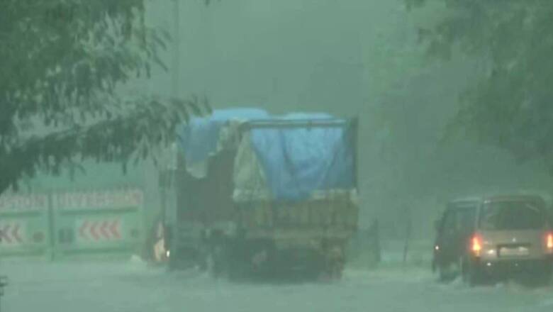
Delhi on Saturday recorded the highest rainfall for 24 hours span during this year’s monsoon season after heavy showers lashed the national capital and its adjoining areas, bringing respite to the sultry weather conditions.
In the last 24 hours from 8:30 am on Friday, Safdarjung recorded a whopping 138.8 mm of rainfall. Roads cutting crucial routes in the city have reported waterlogging and vehicular movement has been hit in parts of the national capital after overnight rainfall.
During the next two hours, a thunderstorm with moderate to heavy intensity rain is “most likely to continue” over many parts of Delhi and adjoining areas, the India Meteorological Department said on Saturday.
Major commercial areas in Pragati Maidan, ITO, Lajpat Nagar and Jangpura saw severe waterlogging, as a result of which, commuters on the route faced severe traffic snarls.
Taking to Twitter, the Delhi traffic police apprised the situation of vehicular movement. While the Azad Market Underpass is closed due to 1.5 feet waterlogging, traffic is affected at Moolchand Underpass for the same. Meanwhile, traffic movement on Minto Bridge (both carriageways) has been closed as the road reported heavy waterlogging.
“Waterlogging at Pul Prahladpur Underpass.Traffic Interrupted at MB road diverted on Mathura road,” Delhi Traffic police tweeted.
Delhi (Safdarjung) reported 73.2 mm rain during 0230-0530 IST of 21.08.2021.— India Meteorological Department (@Indiametdept) August 21, 2021
According to the IMD, these are the areas where moderate to heavy intensity rainfall is expected to continue: Delhi, NCR ( Bahadurgarh, Faridabad, Ballabhgarh, Loni Dehat, Hindon AF Station, Ghaziabad, Indirapuram, Noida, Greater Noida) Kaithal, Karnal, Rajaund, Assandh, Panipat, Gohana, Gannaur, Sonipat, Narwana, Jind, Rohtak, Jhajjar, Farukhnagar, Sohana, Palwal, Panipat, Karnal, Gohana, Gannaur (Haryana) Saharanpur, Gangoh, Deoband, Muzaffarnagar, Shamli, Baraut, Bagpat and Jattari (UP).
On Friday, the maximum temperature was recorded at 32.8 degrees Celsius, a notch below the season's average while the minimum temperature was recorded at 27.3 degrees Celsius, a notch above normal. Humidity levels oscillated between 97 per cent and 70 per cent.
The maximum and minimum temperatures are likely to settle around 32 degrees Celsius and 25 degrees Celsius on Saturday. The MeT department has issued an orange alert for Saturday and a yellow alert for Sunday. The department has issued green alert from August 23 to August 26.
The IMD uses four colour codes: Green means all is well while yellow indicates severely bad weather. It also suggests that the weather could change for the worse, causing disruption in day-to-day activities. Orange alert is issued as a warning for extremely bad weather with the potential of disruption in commute with road and drain closures and interruption of power supply. Red is when extremely bad weather conditions are certainly going to disrupt travel and power and have significant risk to life. On Thursday, the national capital recorded a high of 36.5 degrees Celsius and a low of 27.5 degrees Celsius.
Read all the Latest News, Breaking News and Assembly Elections Live Updates here.


Comments
0 comment